
High Winds, Rain Imperil Weather in New Yorkected – NBC New York
What to Know
- A winter storm is set to arrive in the New York area Thursday afternoon — throwing a wrench into holiday travel plans
- Damaging winds, with gusts up to 50 mph, are expected to grip the tri-state area Thursday afternoon and Friday; heavy rain is expected in and around NYC, while others may see some snow
- Temperatures turn dangerously cold by Friday night, making for icy roads the morning of Christmas Eve; the mercury isn’t expected to reach 30, even, Saturday or Sunday, so they’ll stay that way
A monster winter storm imperiling holiday travel for nearly 200 million across the United States, with airline delays and weather advisories afflicting a broad swath of the country, begins its siege on the New York City area later Thursday.
It’ll stick around through Friday — and potentially deadly cold weather comes in its wake.
The local onslaught of heavy snow, ice, flooding and powerful winds associated with the system affecting people from the Plains and Midwest to the East Coast moves in Thursday midday and continues into Saturday.
The blizzard-like conditions many are set to face will make travel virtually impossible for a full day or longer, and intense winds could trigger power outages that, given the frigid weather approaching, could be dangerous if they last.
The main story with this winter storm won’t be blockbuster snow totals locally, but the extensive high wind footprint. Every state east of the Rockies will see gusts of at least 30 mph, with gusts of 50 mph or higher forecast for the I-95 corridor. Those anticipated winds have already led to a number of airlines waiving change and cancellation fees.
Track live weather radar and travel impacts here as the storm hits.
Storm Team 4
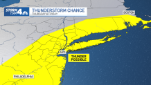
Conditions rapidly deteriorate locally Thursday afternoon, as rain and strong gusts arrive. The rain intensifies overnight and will stay heavy into Friday morning, which could lead to flooding, especially in low-lying and other vulnerable areas. Thunder is possible with some of the heavier rain Thursday night, but widespread severe weather is not anticipated.
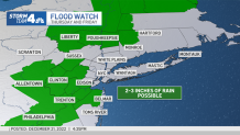
The city could see 2 to 3 inches of rainfall by the time the system moves out.
Coastal flood warnings are in effect for the south shore of Long Island, the Connecticut coastline and the Jersey Shore north of Ocean County. A coastal flood watch has been issued for the city and neighboring counties in New Jersey, as well as Long Island’s north shore. Check the latest weather alerts for your neighborhood here.

Friday is expected to see far-reaching impacts all day long, across the country and throughout the New York area. Temperatures will rise to unseasonable highs near 60 degrees on Friday, but as the rain ends, dangerous arctic air rushes in, plunging the mercury by about 30 degrees within a matter of hours. That makes flash freezing a major concern.
Wind chills will be at or below zero before dark, and temperatures will be in the teens Friday night. Any wet surfaces, including roadways, could quickly turn to ice by the time many get on…
Read More: High Winds, Rain Imperil Weather in New Yorkected – NBC New York