
Tonga eruption’s towering plume reached the 3rd layer of Earth’s atmosphere
Sign up for CNN’s Wonder Theory science newsletter. Explore the universe with news on fascinating discoveries, scientific advancements and more.
CNN
—
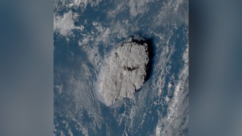
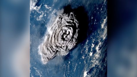
When the Hunga Tonga-Hunga Ha’apai volcano erupted underwater in January, it created a plume of ash and water that broke through the third layer of Earth’s atmosphere.
It was the highest-recorded volcanic plume and reached the mesosphere, where meteors and meteorites usually break apart and burn up in our atmosphere.
The mesosphere, about 31 to 50 miles (50 to 80 kilometers) above Earth’s surface, is above the troposphere and stratosphere and beneath two other layers. (The stratosphere and mesosphere are dry atmospheric layers.)
The volcanic plume reached an altitude of 35.4 miles (57 kilometers) at its highest. It exceeded previous record holders such as the 1991 Mount Pinatubo eruption in the Philippines at 24.8 miles (40 kilometers) and the 1982 El Chichón eruption in Mexico, which reached 19.2 miles (31 kilometers).
Researchers used images captured by satellites passing over the eruption site to confirm the plume’s height. The eruption occurred January 15 in the southern Pacific Ocean off the Tongan archipelago, an area covered by three geostationary weather satellites.
A study detailing the findings published Thursday in the journal Science.
The towering plume sent into the upper layers of the atmosphere contained enough water to fill 58,000 Olympic-size swimming pools, according to previous detections from a NASA satellite.
Understanding the height of the plume can help researchers study the impact the eruption might have on the global climate.
Determining the plume’s height posed a challenge to researchers. Typically, scientists can measure the altitude of a plume by studying its temperature — the colder a plume, the higher it is, said lead study coauthor Dr. Simon Proud of RAL Space and a research fellow at the National Centre for Earth Observation and the University of Oxford.
But this method couldn’t be applied to the Tonga event due to the violent nature of its eruption.
“The eruption pushed through the layer of atmosphere we live in, the troposphere, into the upper layers where the atmosphere warms up again as you get higher,” said Proud via email.
“We had to come up with another approach, using the different views given by weather satellites located on opposite sides of the Pacific and some pattern matching techniques to work out the altitude. This has only become possible in recent years, as even ten years ago we didn’t have the satellite technology in space to do this.”
The research team relied on “the parallax effect” to determine the plume’s height, comparing the difference in appearance of the plume from multiple angles as captured by the weather satellites. The satellites took images every…
Read More: Tonga eruption’s towering plume reached the 3rd layer of Earth’s atmosphere