
Super Typhoon Karding: Philippines on red alert as Noru nears
The storm, known locally as Super Typhoon Karding, reached super typhoon status early on Sunday morning local time in the Philippines after suddenly intensifying.
“The highest emergency preparedness and response protocol has been activated in Metro Manila, Central Luzon, Calabarzon, Mimaropa, and the Bicol region,” said the National Disaster Risk Reduction and Management Council.
It urged the public to take care, adding strong winds are expected to hit within the next 18 hours
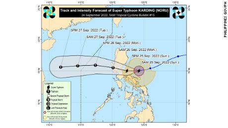
The typhoon is expected to make landfall in the northern part of Quezon or the southern part of Aurora in the evening, said the Philippine Atmospheric, Geophysical and Astronomical Services Administration (PAGASA) on a live hourly television bulletin.
It said it does not rule out an earlier landfall in Polillo Islands in the afternoon.
Schools in multiple cities including Muntinlupa City and Aurora suspended classes for Monday, Sept. 26, due to the approaching storm.
According to CNN Weather, Noru now has winds equal to a category 5 US hurricane.
It is expected to bring large waves and storm surge, torrential rains, and winds in excess of 200 kph (124 mph) to Luzon over the next 24 hours.
PAGASA issued a warning for the Polillo Islands in anticipation of extensive damage that could be caused by the storm.
The warning comes after the storm rapidly intensified in the early hours of Sunday.
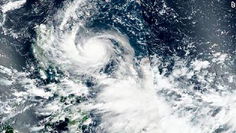
The Joint Typhoon Warning Center said it had strengthened from a 140 kph (85 mph) typhoon to a 250 kph (155 mph) super typhoon in just six hours.
Earlier on Sunday the PAGASA has issued a signal warning level four for the Polillo Islands in anticipation of extensive damage and level two and three warnings for much of Luzon, including metro Manila.
Talas kills two in Japan
One person is missing after his car fell into a river, Shizuoka Prefecture government reported.
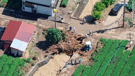
The prefecture saw its heaviest daily rainfall on record, including a record rainfall of 416.5 mm in Suruga-ku, Shizuoka City, according to the Japan Meteorological Agency.
During the downpour, the prefecture urged 1,200,000 households — approximately 3 million people — to evacuate.
More than 1,000 houses and a large number of roads in the prefecture were flooded, it said, adding that multiple bridges have collapsed.
Read More: Super Typhoon Karding: Philippines on red alert as Noru nears