
Periods of Heavy Rain Expected Through Thursday – NBC New York
A “firehose” of rain is expected to drench the the tri-state area for the next few days starting Tuesday afternoon — a damp start to the official start of summer that could bring flash flooding to certain areas.
Although some sun is expected early Tuesday, it will be a mostly cloudy kind of day with temperatures just below 80 degrees.
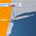
However, there is a chance that severe weather will make its way to the metro area by Tuesday afternoon — with periods of heavy rain through Thursday. The biggest storm impacts will be felt west of New York City.
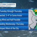
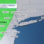
Some areas will see as much as 2 inches of rain by then — with some areas possibly experiencing as much as 3 to 4 inches. As a result, there is the chance for some flash flooding.
Thunder is also a possibility, along with gusty damaging winds, on Wednesday, a day which will also see some chilly weather as temperatures are expected to dip and reach only the high 60s.
The tri-state area will get back to summer weather by Friday after the front makes its way through just in time for a nice weekend with temperatures in the 80s.
Check the latest severe weather alerts for your neighborhood here.
Track upcoming weather using our interactive radar below.
Read More: Periods of Heavy Rain Expected Through Thursday – NBC New York