
Winter storm: From tornadoes to ice, here are the conditions expected in today’s
More than 90 million people are under wind advisories, stretching 1,000 miles from across Alabama to Maine. Winter weather conditions are also threatening to affect more than 15 million people.
Areas from the Great Lakes to northern New England can expect heavy snow and a treacherous icy wintry mix of sleet and freezing rain, the National Weather Service warned Thursday.
“The combination of wet snow and strong, gusty winds will lead to reduced visibility and hazardous travel conditions, particularly for untreated roads,” the weather service cautioned.
Midwest cities including Detroit and Cleveland are under winter storm warnings for snow and ice until Friday morning. Detroit was expected to see peak snowfall rates up to 1 inch per hour, according to the local weather service office.
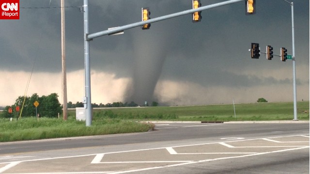
The storm’s impact was already felt in the South Thursday when two tornadoes touched down about 30 miles north of Tuscaloosa, Alabama, the weather service confirmed. Trees were downed on roadways and structural damage was reported. A third tornado was reported in Pell City, east of Birmingham.
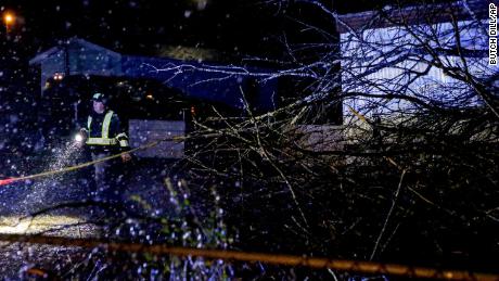
More damage was seen in Fairfield, Alabama, where the rooftop of a BP gas station appeared to have been blown over, and gas pumps were bent, the outlet added.
The storm’s path
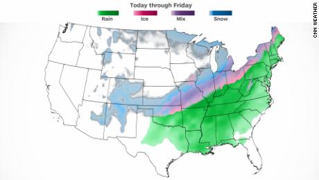
The storm is expected to hit a large swath of the US before it rapidly exists the northeast Friday.
In Buffalo, New York, as much as 5 inches of snow may pile up, with ice ranging from one-tenth to two-tenths of an inch, according to CNN meteorologist Rob Shackelford. Winds may also gust as high as 35 mph. And in Montpelier, Vermont, snowfall may reach 4 inches, joined by ice up to one-tenth of an inch, he said.
The primary threat with the storm appears to be damaging winds, expected to strengthen as they blow eastward. Millions from Louisiana to Virginia are at risk for severe storms.
“Damaging winds and a strong tornado or two will be possible,” the Storm Prediction Center (SPC) said.
More specifically, strong winds are likely in Memphis, Nashville, Murfreesboro in Tennessee, Huntsville in Alabama and Jackson in Mississippi. Those cities are under an enhanced risk, Level 3 of 5, for severe storms.
“Wind gusts up to 50 mph could lead to power outages where trees have been weakened by recent ice storms, as well as hazardous travel conditions for high profile vehicles.” the SPC warned.
CNN’s Judson Jones, Gene Norman and Greg Wallace contributed to this report.
Read More: Winter storm: From tornadoes to ice, here are the conditions expected in today’s