
8-16 inches forecast for southeast Mich; cities prepare
Winter storm forecasts for this week are becoming clearer, with the National Weather Service putting southeast, central and southwest Michigan under a winter storm watch for significant snowfall.
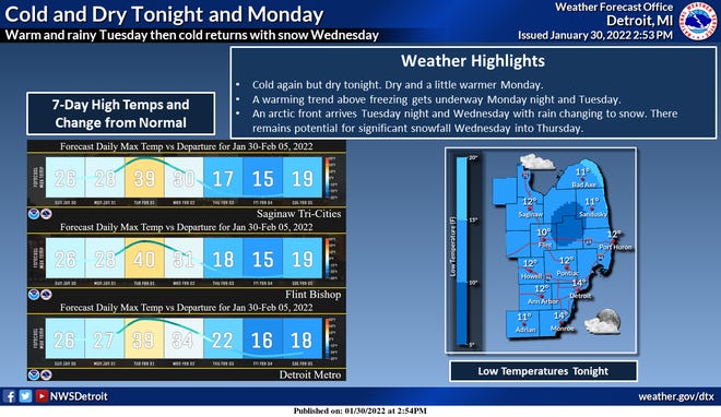
“A long duration of light to moderate intensity snowfall (is) expected between Wednesday morning and Thursday evening,” according to the NWS for southeast Michigan. A winter storm watch in effect from 4 a.m. Wednesday through 11 p.m. Thursday predicts as much as 8-16 inches.
The watch includes Sanilac, Shiawassee, Genesee, Lapeer, St. Clair, Livingston, Oakland, Macomb, Washtenaw, Wayne, Lenawee and Monroe counties in southeast Michigan with up to 16 inches south of Interstate 69 corridor from late Tuesday through Thursday evening.
In Berrien, Cass, Branch and Hillsdale counties in southwest Michigan, the service reports predictions of 6-12 inches of snow, and in Clinton, Allegan, Barry, Eaton, Ingham, Van Buren, Kalamazoo, Calhoun and Jackson counties in central Michigan, with predictions of 8-12 inches.
The storm is part of a weather system that is expected to hit 90 million Americans in 14 states over a 2,000 mile stretch, Accuweather reported. The storm is expected to disrupt travel and the nation’s supply chain, which “could be felt for weeks,” said AccuWeather Chief Meteorologist Jonathan Porter.
Temperatures early in the week will be relatively mild, with 40 degrees possible in southeast Michigan, and the precipitation Tuesday night likely will start as rain. That will change quickly to snow, according to the NWS, and persist for all of Wednesday and for much of Thursday.
“The overall setup really sets the stage for a potentially significant amount of snowfall over roughly a 48 hour period,” the NWS said, adding “at least moderate potential to exceed 8 inches as far north as the I-69 corridor/Sanilac county, with a foot+ certainly in play across southern sections of the watch area.”
Chances for snow in southeast Michigan on Wednesday and Thursday are nearly 100%, according to NWS. After the snow, bitterly cold temperatures are expected. Rain is expected to change to snow and increase Tuesday night and early Wednesday. A “prolonged persiod of snowfall” will continue Wednesday into Thursday. Gusty northerly winds will contribute to blowing snow.
While all snow is expected in Michigan and in northern Indiana and Ohio, some areas south will see a higher potential for freezing rain.
Meteorologists say the exact track of the storm has yet to be determined, but southeast Michigan could see blizzard conditions.
The early storm alert has prompted some Metro Detroit communities to issue warnings to residents.
The city of Highland Park told drivers to park “in the driveways, garages, and lots,” not the street, so salt and plow truck drivers can work.
“All snow will be plowed to the north side of most residential streets,” officials said in a statement Monday. If you have to park on the street, please be mindful that you may be plowed in.”
Dearborn Mayor Abdullah Hammoud has declared a snow emergency for the city starting at 1 a.m. Wednesday. It was expected to end at noon Friday.
All vehicles must be removed from the streets by 1 a.m….
Read More: 8-16 inches forecast for southeast Mich; cities prepare