
‘Paralyzing’ snow rates likely as winter storm ramps up in DC area
“Look for snowfall rates of 1 to 3 inches per hour,” Storm Team4 meteorologist Mike Stinneford told WTOP. “This is going to overwhelm the snowplows … a paralyzing amount of snow is getting ready to move in from the southern suburbs, and a lot of us are not gonna be able to move.”
Key points:
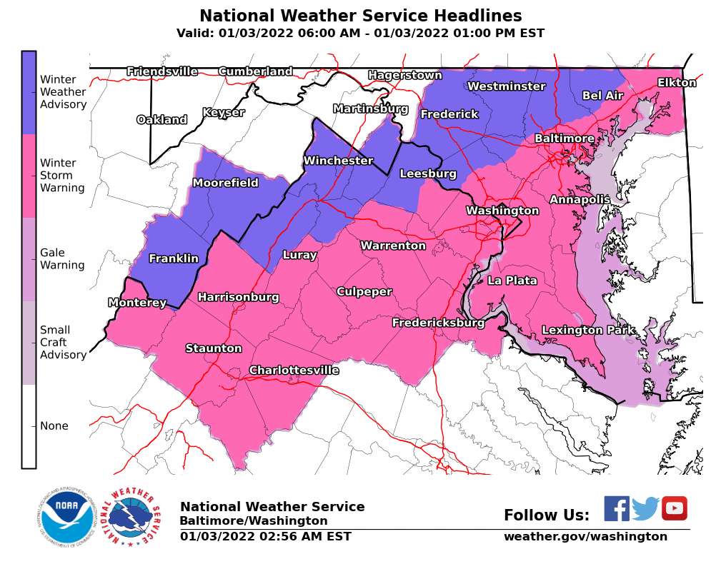
- A Winter Storm Warning continues for much of the Washington and Baltimore metropolitan area until 4 p.m. Monday.
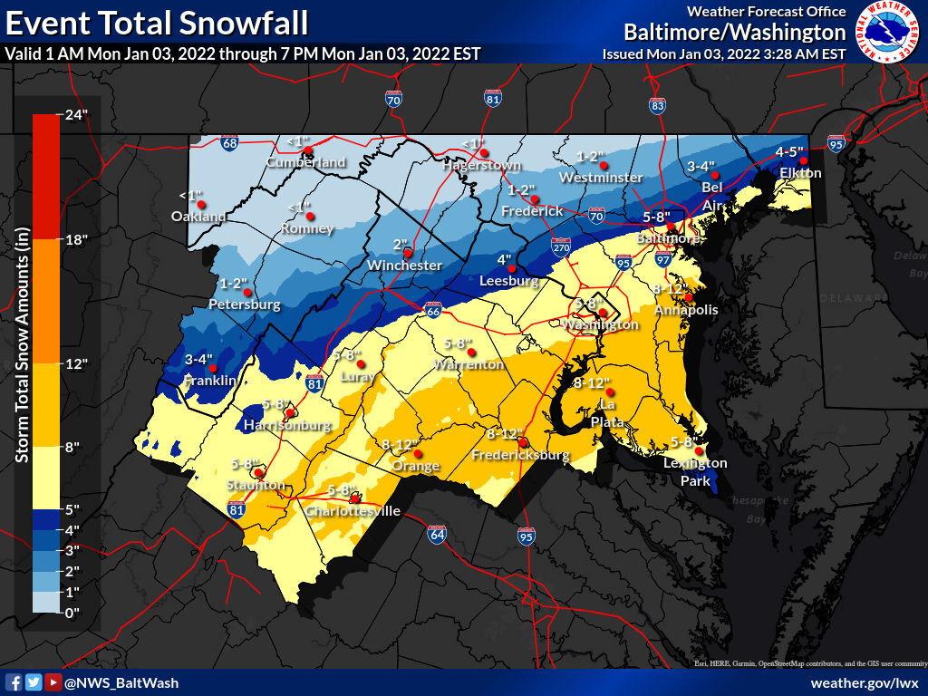
- Totals: Between 5 and 10 inches in D.C. and Baltimore, with 1 to 4 inches in northern and western suburbs, and higher amounts south and east.
- The heaviest snow will fall between 7 a.m. and 11 a.m. with snowfall rates of 1 to 3 inches per hour possible.
- Federal offices and most public school districts are closed. See WTOP’s full list of closures and delays.
If you were planning on hitting the roads this morning, our best advice is, quite simply, don’t: The D.C. region’s first winter storm of the season will ramp up drastically over the next several hours, poised to slash visibility and paralyze traffic for the rest of the morning.
“Look for snowfall rates of 1 to 3 inches per hour,” Storm Team4 meteorologist Mike Stinneford told WTOP. “This is going to overwhelm the snowplows … a paralyzing amount of snow is getting ready to move in from the southern suburbs, and a lot of us are not gonna be able to move.”
Between 5 and 8 inches are likely by Monday afternoon for millions from D.C. to Baltimore. Snow was falling steadily across the region by 7:30 a.m. with one particularly intense band stretching from Fredericksburg over the Potomac to Waldorf.
A Winter Storm Warning is in effect for the Washington and Baltimore metro areas. Those near or south of Interstate 66 and U.S. Route 50 will see the heaviest snow fall from mid- to late morning with the forecast calling for up to 10 inches. Points north and west, including parts of Loudoun County in Virginia and Montgomery and Howard counties in Maryland, are under a Winter Weather Advisory for more modest totals of 3 to 5 inches.
Driving will be treacherous, especially within heavier bands. Plan on slippery conditions and visibility below one-half mile. If you must head out Monday, drive slowly, make way for plows and use caution on steps, sidewalks, driveways and streets. Beware of roads refreezing Monday evening into Tuesday morning.
Computer models continued nudging the storm’s path to the north overnight, bringing D.C. and Baltimore proper under the bullseye for a major winter weather event.
But while the odds of a significant event have trended upward for urban areas, uncertainty remains over how far north into the suburbs the worst will make it. Forecasters are eyeing a sharp gradient at the storm’s northern edge, and any last-minute nudges could mean a big difference in totals for Central Maryland and parts of Northern Virginia.
The precise setup of heavier snow bands are also notoriously difficult to predict, and that too could be a determining…
Read More: ‘Paralyzing’ snow rates likely as winter storm ramps up in DC area